Sydney After Dark: Photos of Surry Hills at Night

Being back in the city has offered a change from the landscape photography of the last few months. I  have been trying my hand at some night photography in the neighborhood.  The following photos have been taken on Crown St. An active part of the Surry Hills neighborhood, Crown offers an array of shopping, food, and bars.  There is a constant hum of activity throughout the day and night, and Crown has a flavor that is unique to Sydney.

As I get more acquainted with Sydney, I hope to share some of the city through my lens, so stay tuned check out my flickr out for some more photos….and enjoy! Thanks for swinging by!

Aussie so Far…

Australia is big.  Very big.  Still no excuse for the big lag in between posts, but now that the dust has settled it is probably time to catch up.

Getting settled over the last few months has meant getting adjusted to being back in a country that is almost the size of my own.  Traveling for hours to get from one destination to the next, living in a big city again, wearing shoes… all things that I had sort of forgotten about while spending my time in NZ.

On May 22nd, Mac and I landed in Gold Coast airport.  A 45 minute drive south took us to our first Australian destination, beautiful Byron Bay.  Life was pretty easy here.

The biggest difficulty that exists in Byron is trying to stay productive.  Luckily, it seems like noone in town really minds taking it a bit slower then the rest, so relaxing is not a problem.  Hours melt away on the beach as days pass by unnoticed, soon turning into weeks.

The activities you find to fill up your day always involve the beautiful coastline and rocky outcropping of the eastern most point in Australia. Surfing, snorkelling, and sunbathing were always high on the ‘To Do’ list.  Frequent walks down Main Beach into town, and a bit further of a hike up to the lighthouse offered views of stretching coastline and the chance to see some ocean wildlife. From a vantage point at the lighthouse, spotting humpbacks migrating north and pods of dolphins playing in the surf became an almost daily occurrence.

Image

Surf at the Point; Byron Bay

Surf is the main priority here, the kind of place where locals cycle through town on beach cruisers modded to carry a surfboard on the side, while the ultra hip ride in 1960s era cars and VW Filmores with a board or two attached to the roof.

The town itself mimics its people, with an array of kitsch shops, bamboo laden surf stores, and laid back open air cafes that buzz. Walking along the street, it’s easy to catch a tune along sidewalks as buskers strum, drum, and pick their way through the day. As the sun sets, crowds gather along the beach to watch the sky reveal its colors as the day burns into night.  Patio bars fill with patrons and local acts take the stage; town nightlife speeds by, while beach fires flicker on the shore.

A lucky break landed me a gig driving the hostel shuttle bus to and from town, giving me free rent and allowing my carefree Byron lifestyle to continue.  All in all, a great start to Australia, but more of a temporary stop while the hunt for work continued.  

With employment looking fairly bleak in town, Mac made the decision to try his luck up north, about two hours from Byron.  Our trip over the last 8 months covered 2 countries. We lived in hostels, mountain homes, garages, eco retreats, the occasional drunk english girl apartment floor, and tents.  We planned, mapped, hiked, kayaked, biked, skied, climbed, and surfed. Taco Tuesday, fires on the beach, sake bombs, paying for the views, mousetraps in the car, fishing with rocks… he was a solid partner to have and it was a definitely a bittersweet ending to our travels together. 

Mac N Cheese

Ol’ Mac n’ Cheese Posing for the camera; Auckland NZ

I was happy to know he was leaving with the intention of reaching for his own goals, but sad realizing that a chapter of this trip had closed.  We parted ways with the promise of meeting up for another adventure soon.

Meanwhile, my own job search turned me to a contact I had from The States, with my old employer, Patagonia.  A few emails and phone calls later and I had found myself with them yet again, working at the flagship store in Sydney. Exciting to be employed, especially with a great company.

Sydney sits around 800km, or a 12 hour train ride south from Byron.  It was a goodbye to the easy lifestyle of Byron, and a big flip heading into the big city again.  The birdsong quickly dissolved into the roar of traffic and people.  All part of the adventure though, and it feels good to start over in a city.  There is still plenty of beaches close by, and the mountains are only a few hours away.   Anytime the concrete jungle gets a little too intense, there is an escape nearby.  For now, its getting back into work, saving, and planning for what lies ahead. Image 

 Surf at the point, Byron Bay.

Thanks for the traffic, and keep up on flickr,  whoop dee whoop!

You want a List? O I’ll give you a List…

That’s it, its over.  We are packed up and ready to board.  It’s been swell New Zealand, you’ve treated us right, and we have learned a few things along the way.

The following list is my own personal “Tips for travelling in New Zealand”.  A list that has been built thousands of times by a countless number of travelers.  Still, each one holds a unique perspective.  So here it goes, let’s do this before I get too choked up….

Stay left

-Let’s start simple and easy.  If you’re arriving from a country where the traffic flows right, then it’s going to take a few days to get used to.  Start off slow, look right then left before you cross the street, or just to be safe look both ways 3 times and still not have a clue what is going to happen. The next step is to realize that everything and everybody flows on the left.  This means that when walking down the street into an oncoming crowd you are going to veer left, not right.  Sounds easy right?  Tell me that after two days of doing the sidewalk shuffle with every person that walks by, you dumb American.

O yea, and going up on an escalator?  Save yourself the trouble and look to the left for the UP stairs, trust me.

Take showers
-Mmmmm Hot showerrrrs.  There are going to be times, when its not available, and a lake or creek on the trail after a long day hiking may just have to do.  But when you do stumble upon the campsite that offers the sweet sweet goodness of a hot and free shower, stop immediately.
Let me explain.  Some of the campsites will charge up to $2 for a 6 minute rinse that leaves you with a salty tear rolling down your half rinsed, still soapy cheek.  When you do come upon the lunatic camp manager who allows his patrons to shower at their own pace take one, no take two, aw fuck it; take as many as you can over the next twelve hours.
The universal rule of the road is that showers cumulate.  So if you have 3 showers on a Wednesday, by law, you are good until Sunday.

DSC_1970

Don’t forget to bring a towel.
-If someone where to ask me what my #1 most effective and useful piece of gear has been the answer is simple.  My purple REI camping towel has done more for me in the last 8 months then the college degree tucked away in my childhood bedroom (if only it were made out of super absorbent material maybe I could have it mailed out…)
This bad motha has done service as a blanket on the beach, a shield from the wind, a dryer of dishes, and an emergency pillow.  Get one that packs light, and dries fast, you will be holding onto it like your childhood softie by the end of the trip.

Towelie

80 dollars for a T-shirt?
Economies of Scale people. Low population + high import taxes + low quantity of goods = High costs for everything.
If you are coming from The States expect to pay about double or more, for everything.  Europe, probably going to be around 1 ½ times more expensive.  For that reason alone, gear up before you get here.  You are guaranteed a better deal if you get it back home, and most of the time you will find yourself ordering to someone in the States and having it shipped for a lesser price then you could purchase here.

Save money, learn to cook.

Food costs money, especially when you can’t cook.  Average dinners out here are going to run you about 25-30 dollars, so if you don’t want to go broke in a month, then learn how to turn on a stove.  It also helps when you get the craving for comfort food.  Can’t find a decent slice of pie or a burrito for under $24 (I’m not kidding, this is how much they cost) then make ’em yourself.  You’ll be doing it at a fraction of the cost, and it’s going to taste better when it’s fresh.  Thinking about homemade fish and chips though, don’t even try it.  Leave that one to the pros…DSC_1824 DSC_1861

Homemade Stromboli and Taco Tuesday. Church, bitches.

It’s not about what you know, it’s who you know.
-Other than a towel, this may be the most important piece of advice that I have surmised from the trip.  From finding the nearest grocery store, the best overnight hut to hike to in the local area, surf spots, cult beer bars, a couch to flop on for the night; all of these are achieved by talking to people.  Chatting up folks from town to town, site-to-site, I have gained more insight and local scene then a guidebook could have ever told me.

The weather outside is weather.
-Especially if you are sleeping in your tent, check the forecast. Then walk outside, and forget everything you just heard, and look up.  NZ is notorious for it’s spotty weather patterns, and the only law that applies is Murphy’s.  That means on a sunny bluebird day, you still better stake down that fly nice and proper, because there is always a chance of waking up in the middle of the night to a downpour.

Internet ? What Internet?
– Ughhhhhh, no wifi, like anywhere?  I mean a coffee shop, you really want me to pay for 10 minutes?  The library charges for wifi?  But, my fantasy league… and if I don’t Facebook my trip, then it really never happened….Why have you Forsaken me????
Sorry guys, but when you come to an island on the bottom of the world, one of the closest neighbors to Antartica, sometimes it’s going to feel like it.  Free wifi is tough to find here.  In 8 months, we came across 3 coffee shops, a few public libraries, and a handful of hostels that allowed unlimited access for free.  That means the latest news about Kim and Kanye is going to have to come the old fashioned way; the magazine checkout rack at your local grocery.  Don’t worry; those crazy cat videos will still be there when you get back.

26ph
*McDonalds offers free WIFI all over the country, but really for the 2 hours of your life you shaved off by eating that Big Mac, why don’t you just pony up a few bucks at an internet café to check your email?

If there’s a fork in the road, take it.
This might be an obvious one, but the signs here don’t lie.  Some of the best things I have seen in NZ have been on a whim, a simple detour on the way.  The roads are well marked with plenty of natural wonders, kitschy shops, and odd towns.  If you got the time (if you are in NZ, then you have the time) take some turns off the beaten path.  Get lost, you’ll be glad you did.

On departure to Australia, I am tempted to pour my heart out. Thinking back on where I started, who I have met, and what I have become, it would be easy to become all emotional about the last 8 months.

To keep it simple though, at the end of it all, I just finished up on a pretty damn good vacation.

I think it might be better to leave it at just that.

Just cause I’m leaving NZ doesn’t mean I am finished, more posts and pictures are coming soon…next stop Aussie-town! Have a look at my flickr and tell me what you think!

North Island Antics

Our trip on the North Island began in the town of Wellington.  After 8 months away, it was great to be back in a city again.  I didn’t think I would miss it that much, but enjoyed being around the people, noise, and hustle of a city life.

When visiting Wellington, you can’t miss Te Papa museum.  Host to much of new Zealand’s diverse cultural history, it is worth a full day of exploration. The largest intact species of a colossal squid, Maori artwork, life size recreation of Moa, and most importantly the exhibit below, which could be one of the most significant pieces of scientific advancement of our time.

DSC_1829

Most likely the ‘new guy’ trying out the helmet. 

Te Papa is only one part of the ‘Welly’ experience.  Exploring the hills around town, we stopped by a few farmer’s markets, went to Parliament, saw the famous cable cars in action,  and grabbed a few beers at one of the many hip watering holes around town.  If you are into your craft beers, then Hashigo Zake is the joint to grab a cold one.  A funky place, located in the basement of a near-by alley, these guys pride themselves on their knowledge of hops and barley.

DSC_1839

Wellington Cable Cars

One hangup about cities everywhere, is they aren’t exactly suited for a backpacker’s budget.  A few days of living there sent us on our way, back to the tents, and simple lifestyle that we have grown accustomed to.  On the road and heading northeast, we reunited with our flatmate from Queenstown; Ben Marshall and his lady in the small town of Te Awanga.  The town is surrounded with some of NZ’s most famous vineyards, bringing in savvy wine tasters from all over the world.

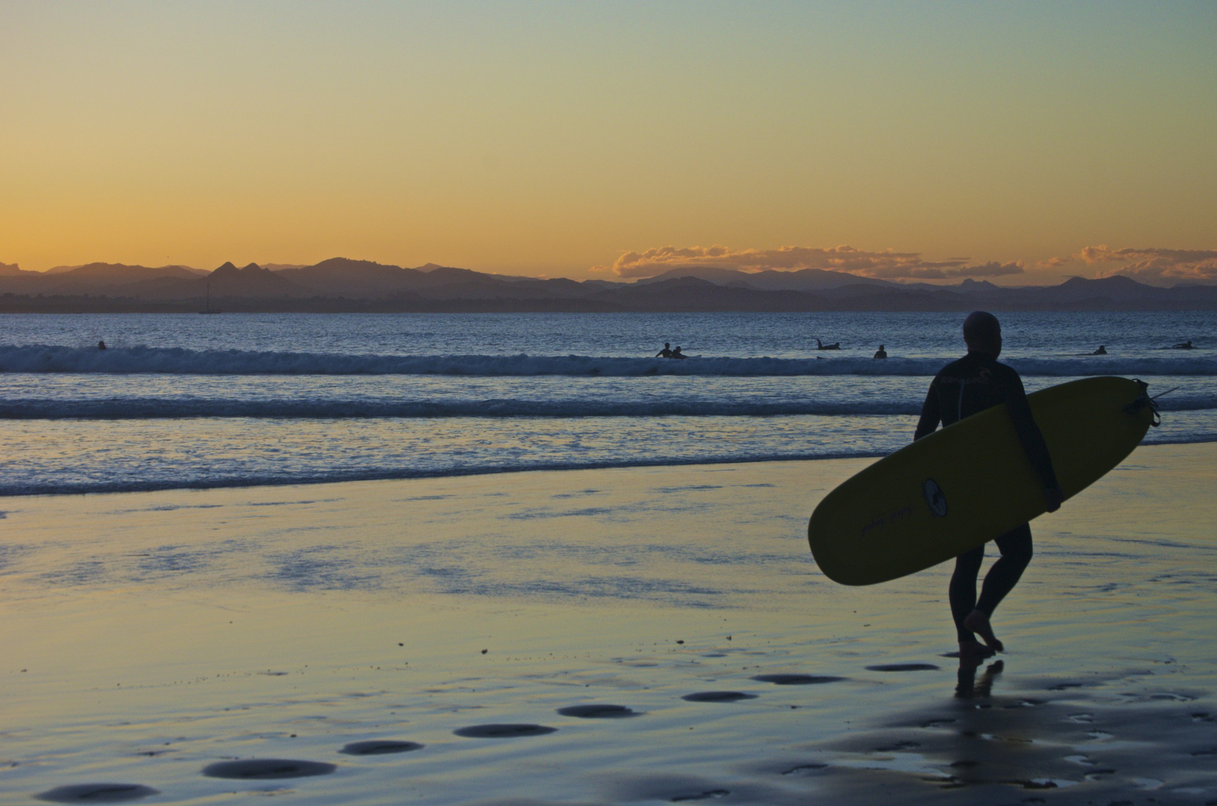
The beautiful countryside leads right up to the coast, where the swells draw a bit more disheveled surf crowd, who often end up picking the grapes that satisfy the upper crust wino’s palette.  Marshall and Prue, both surfers, convinced us that staying here would be the best option for the next few days.  A few days, however, soon turned into over a week.  

DSC_189

Marshall riding out a wave at Te Awanga

With a little pep talk from the seasoned vets, we paddled out into the surf.  Like any first day, there is a learning curve.  Surfing’s curve is steep, but there is no denying that it is addictive. The feeling you get, sitting on your board past the break, rolling with the waves,  is a peaceful and calming effect that only the rhythm of nature offers.

DSC_1762

Waimarama Beach near Te Awanga

DSC_1761

The crew at Waimarama, and the only part of surfing that I have mastered so far.

All good things must come to an end, and after 9 days we decided to move further inland, towards the volcanic activity that gives the North Island its reputation.  A day’s worth of driving deposited us near the Tongariro Crossing, the volcanic walk that North Island is known best for. There are plenty of adjectives to describe this place, quite simply put, it was incredible.

Three volcanoes are visible throughout the trail; Tongariro, Ngauruhoe, and Ruahepo.  Ordered from lowest to highest in elevation, Ruahepo also has the distinction of being NZ’s tallest active volcano.  Weather was finicky, and it was questionable whether we were going to be have a view of any of the volcanoes, let alone attempt the crossing.  An overnight wind provided us with a very lucky break, yielding bluebird skies and low winds in the morning, offering a window to summit Ngauruhoe at 2291m.

DSC_1827

Ngaurahoe summit from the base

This is the most conical shaped volcano in the Tongariro Crossing, and also the filming location of Mt. Doom in the Lord of the Rings movies.  The climb takes you to the edge of the crater at its summit with Ruahepo’s snow covered peak in the not too far off distance. Needless to say, the view was spectacular.

DSC_1782

Ngauruhoe Crater with Ruahepo in the distance

Along the trail to the summit, vents blew steam into the sky, making a statement about the natural wonder that you stood on and served as a reminder that all three of these volcanoes are still very active, with Tongariro erupting as early as this past November.

DSC_1795

From the summit

The summit climb was moderately difficult, with slippery footing due to the scree and ash. What it lacked in the climb up, however, made up on the way down.  The soft ash cushioned your footing, which made it possible to pick a line and send it.  Our ascent took over an hour, the descent was about 15 minutes.  That will go down as easily the best and most fun way to get down a mountain without a snowboard that I’ve ever had.

DSC_1845

Ngauruhoe

Further along the Tongariro Crossing sit the Emerald Lakes.  Each of these lakes hold a different hue of green or blue, due to the sulfur content that each one of them contain.

DSC_183

Emerald Lakes

As we continue to push North towards Auckland, Fall is starting to settle in.  It seems that we are chasing the warmer weather, but it is starting to cool down enough at night that layering up is becoming a necessity. Only a few more weeks of that though, before our flights to Australia on May 22nd dip us right back into the warm weather climate, and surf that we are now craving.  If you can’t have a winter on the mountain, then it looks spending it on a wave is going to be the next best thing.

DSC_1863

Thanks for the read, and the ‘likes, don’t forget to follow, and check out more pics on my flickr!

So Long South Island

Finishing up the last few weeks on the road in the South Island gave us plenty of great memories to carry  to the North Island.

Kayaking the Abel Tasman provided us with picturesque campsites where the turquoise water stretched along golden sand beaches.  The days were spent snorkeling the marine reserve of the park unveiling an array of fish, starfish, and stingrays.

Abel Tasman National Park

Abel Tasman National Park

Sunset at Mosquito Beach

Exploring around the Golden Bay area North of Nelson and Abel Tasman, we discovered the art of frossicking.  It involves a low tide, a keen eye and as many mussels as you can grab.   Mix in some local veggies and the resulting reward; a seafood pasta that doesn’t get any fresher.

Seeing a fork in the road and taking it is the best part of traveling.  Nelson will go down as the spot that produced the most options, and allowed us to key in to the local scene.

An evening with captain Geoff and the rest of the pirate sailing team allowed us the chance to test our sea legs (and sailing vocabulary) on the Tasman Sea, in addition to a bit of post trip dock party.

Sailing on the Abel Tasman

Another lucky break involved a thirst driven stop at the local alehouse.  This gave us an opportunity to volunteer at Marchfest 2013, Nelson’s annual micro brewing event.  Any previous thoughts about the kiwi’s lacking good beer were quickly dissolved at the festival.  15 craft beers were unveiled from surrounding area breweries.  Our volunteering stint gave us a great shot at trying just about all of the beers and a taste of food from local vendors.  We ended up hitting the bars with a group of local friends afterwards, which added up to a slow and nauseating Sunday exit from Nelson.

On the outskirts of Nelson lay the beautiful Marlborough Sounds. The roads twist, bank, and wind up and along the numerous peninsulas and islands of Marlborough.  The road pinches itself tighter around corners, a few near misses from oncoming traffic remind you to stay tight in your lane (or whatever is left of it at some points) and keep an eye out for upcoming turns.

Marlborough Sounds

We made our way up to Mt. Stokes on one of our last days.  Stokes is known as the highest point in Marlborough Sounds, the only peak that sits above tree line. From this vantage, the vast stretch of land covering the sounds feels a bit surreal.  Appearing as if the South Island is reaching towards the North, fingers of land outstretched to grab hold and pull the country back to the singleland mass it once was. Mt. Stokes

The following day, our view of the sounds changed from aerial to sea level.   Our exit point for the North Island was a ferry departure from the town of Picton.

On the Ferry

Even on the way out the South Island stays beautiful.  Writing from the deck of the ship, I can’t help but feel a little lost as the South Island fades from view.  This was the starting point, what has culminated in the last 7 months has been the story so far.  From landing in Queenstown, finding jobs, meeting friends, to sleeping in our tents, traveling from site to site, picking our adventures along the way.

The kiwi way of departure once again tends to capture nature in all of its glory.  The ferry winds its way through the Marlborough Sounds, before crossing the Cook Strait into New Zealand’s capital city of Wellington.  Islands covered in everything green sprawl across the ocean.  Views of newly snow capped peaks showing first signs of the cooling temperatures stretch to the horizon down the coast.

Of course the same excitement of the unknown waits on the North Island.  A trip like this will always pull you in both ways.  The amazing places you’ve been make you want to stay forever, while the thirst to explore that got you there inevitably arises, and urges you forward.

 For some more pics check ’em out on my flickr

The Great American New Zealand Road trip: Coastin’

The last few weeks have taken us from Queenstown to the Nelson, the northern part of the South Island, where we are rooted for the next few weeks as we seek out adventure along the coast.  As the distance between Queenstown grew, the realization of our adventure had begun to set in. Our roots in Queenstown allowed us to become ‘locals’ halfway across the world. Being on the road again, we opened ourselves up to the rest of the country, and were anxious to see where it would lead us.
As you head North on Highway 6, the only highway heading up the West Coast, you find yourself on an incredible drive.  The road rolls across high mountains peaks, soon after bending onto the coast line and stretching out along beautiful sandy beaches before you dip back into the shady rainforest. Heading North, we passed through both towns of Fox and Franz-Josef, which you gain access to glaciers of the same names.
Fox Glacier
Although beautiful, Franz and Fox’s easy access lends itself to a high tourist population.  We have been lucky enough to find some paths off the beaten track, Mt. Brown being the stand out so far.  Built by the local community, the hut just below the summit of Mt. Brown, with views to the west of the ocean, and several mountain ranges in all other directions.
Mt. Brown
The popularity of Highway 6 up the coast, means that there is plenty of places to camp along the route.  Each of the sites is located near the road and soon fills with travelers.  The majority are the mid twenties adventure seekers, who lead the way in camper vans, and mostly 90 eras cars, both rented and purchased for the road trip.   All have their distinct squeaks moans and pops that serve as audible reminders the automobile has survived more than one trip up the coast throughout its existence. Older couples in ‘flash’ RVs that sound as comfortable as they look, are soon to follow,  with all the luxuries and space that you could ask for.   The most dedicated traveler of the group has to be the cyclist. You soon find these intrepid travelers leaking into the site, mostly solo or in small groups, saddlebags containing all the gear for life on the road.
Driving the west coast line and you quickly realize just how arduous of a journey the are on.  A day of peddling mountain passes or battling seaside breezes, even occasionally tackling both at once earns them the well needed rest they get in camp.
As camps begin to pop up for the night  a buzz starts to fill the air.  Languages and people from all over the world make your head spin as you wander through the sites.  People who didn’t exist in each others lives until minutes earlier, are now helping one another set up camp sharing supplies, swapping stories, and sipping drinks as if they have been friends for years. 
Thus far, we have found adventure from sunset to sunrise.  From bagging peaks one day, to enjoying company of travelers with a beachside fire the next.  Coastin’ all the way, and enjoying every minute of the trip.
DSC_1805

Thanks for reading as always, like they say a picture says a thousand words…so if you feel like hearing a few thousand more, check out my flickr account!

The Great American New Zealand Road Trip

A few hugs and goodbyes later, and we find ourselves in almost the same place as we were six months ago.  Now that its home, leaving Queenstown delivers the same anxious feelings that were around when we first boarded our plane from the States.  The car is packed, our route is mapped out, and we are ready to do a little road trippin’.  Our plan (if you can call it one) is to travel the west coast of the South Island up to Nelson.  We are going to explore and hike along the way, so surely there will be plenty of pictures and stories to tell.  From Nelson we will head over to the North Island, where after some more trekking and sightseeing it’s off to Australia for the start of a new continental adventure!  

Midget Dolphins, Sunsets, and Penguins; a little bit of everything in the Catlins

As our trip continues, we made the decision to purchase a car to make our journey around the country a bit easier. A few weeks of looking around we were able to purchase one for the rest of our time in New Zealand. Its good to be mobile again, and cars run fairly cheap, as we were able to pick ours up for about 1200 NZ dollars. Searching for the right place to take our first road trip we settled on Catlins Conservation beach and forest on the South Island.

Heading out on Wednesday night with Mac and another friend in the car to make the 300km trip down south, we soon put the mountains behind us and headed into the plentiful farms that dot the landscape throughout NZ. From soaring mountains to immense coastal vistas, our trip took us only 3 hours by car.

Arriving at our campsite in Curio Bay, we met our flat mates and friends who had already made the drive earlier in the day. Cold beer, excited talk about our location, and a breezy night was an indication of things to come in the next few days by the sea.

Image

A quick walk the next day to Curio Bay revealed a Petrified Forest, one of the largest known in the world. Stumps and petrified wood lay embedded in the rocks where the sea had receded during low tide, giving us time to explore the ancient landscape. Later on, we would find that this was also the habitat for one of New Zealand’s endangered animals.

Curio is known for its population of Yellow Crested Penguins that nest on its shores at night. Each night people gather from a viewing point to watch the penguins return from a day of hunting at dusk. The penguins seem to pose proudly and knowingly for the crowd, as they slowly waddle across the brown, barren Petrified Forest into the flax above where they nest for the night.

Image

On the other side of camp lay Porpoise Bay, a sandy beach that stretched about 5km around the entire bay. With the sun out and everyone ready to explore we headed down to the beach for what would be the highlight of the trip.

Porpoise Bay, is rightfully named because of the pod of Hector’s Dolphins that call it home. One of the world’s rarest dolphins, with approximately 7,000 of them still in existence, they tend to spend their days swimming in the bay, due to the safety and feed available. With a little bit of patience and stealth, we were able to get within touching distance of the dolphins as they played alongside us in the water. They are easy to spot due to the clarity of sparkling jade water contrasting their dark gray and black mottled skin. As waves rolled into the bay, some would contain small groups of the dolphins, surfing and rolling in the frothy break. The dolphins could be heard as well, as they breached often with a quick inhale of air, before diving and swimming back out to catch another set.

Soon after the dolphin experience we made our way out to a rockier part of the coast near camp. A heavy swell was releasing its power against the rocks, with a thunderous slap that could be heard throughout the campsite. Deciding this would be a good spot for a group photo, we cautiously approached the outcropping, choosing one of the drier spots on the rocks to take a photo.

Image

It wasn’t long though, before we realized that the swells unpredictable power was much larger than what we had guessed.

Image

As dusk approached, the temptation to find a good spot for the sunset was something that couldn’t be missed. A 20-minute hike through some farmland and up one of the massive seaside cliffs that run up the coast yielded a beautiful spot to watch the day give way to night. As we waded through the long grass that swayed in rhythm to the waves crashing against the cliff walls, a flock of birds dove and swooped towards their nests to settle for the night. A sublime calm overtook the group as the sun dipped below the horizon, painting the sky with an array of soft evening color.Image

The following day we said goodbye to a large part of the crew and Mac and I continued around the coast. Heading north, we passed through much of the forest that surrounds the coastline. Giant ferns and moss dripping from the old growth forest gives a feeling that you are trekking deep into an ancient world. We arrived at Mclean Falls, a moderately high waterfall with plenty of tiers for the water to steeple down into a pool before rushing into the creek.

Image

A quick jaunt north from Mclean and we arrived at Nugget Point. The 900m path to the lighthouse is tucked close against the rock walls that sit a few hundred feet above the shoreline. Although a popular path, no ropes or barriers exist to stop you from an accidental misstep that would lead to a few hundred foot tumble to the sea. Jutting out giant boulders, or ‘nuggets’ emerge from the ocean, hence the name given to the lighthouse.

Image

Some quick snaps and a hike back to the car for a look at the map, we headed due south for our campsite located at Purakanui Bay (pronounced Peer-a-kah-new-EE). Purakanui had a number of people at the site, which by New Zealand standards would be a crowded campsite. A drive up the seaside cliff provided us with an isolated spot to enjoy another sunset by the sea.

Image

Soon after building camp a group of surfers with the same idea of escaping the crowd found there way up to our campsite were we all sat down for some campfire chat. Native Kiwis (similar to Colorado, it is a rarity to find someone who is actually native) they introduced us to the New Zealand seafood Paua, a type of shellfish that are located all over the South Island coasts and can be harvested in the plenty, if you know how to look for them, which we later found out wasn’t as easy as it sounded. They generously shared portions with us and we eagerly made the decision to go hunting for them the next day.

Packing up early and heading off in search of our own Paua took us to Long Point, a secluded beach that we were able to claim as our own for much of the afternoon. Gearing up in some borrowed wetsuits and heading into the ocean with a knife, rock, and booze-laden advice from the night before we initiated our first hunt at sea. Largely unsuccessful searched the surrounding rock and bull kelp for a hint of the delicacy of the night before. Excited just to be trying, we marked it as another adventure and one that we will have to try again. As our wetsuits dried and we made ourselves comfortable on the ‘private’ beach that we held as our own, the isolation of overwhelmed me. I couldn’t help but wonder if we were even allowed to be there.

After a few hours of sun bathing we headed back to Queenstown. Watching one landscape slowly fade into the other it began to occur to me, that maybe the isolation wasn’t really that unusual. We had in fact just traveled to the southern most point in New Zealand, effectively what is the southern most populated place in the world before Antartica. Just thinking about that gave me a chill (no pun intended). On one of our treks we past a plaque with a poem that best sums it up:Image

Just one more adventure in New Zealand, with plenty more to go.

As always, thanks for reading, any suggestions or comments are welcome, and for more of the pics check out my flickr account.

High Water and Wanaka

Staying occupied in an unseasonably rainy season can be tough.  It’s hard to stare out of a window on a rainy day half way across the world and not feel like you are wasting an opportunity. 

Still, with all the rain the temptation of the landscape is too much to sit inside all of the time.  We took a much needed road trip of 100km north to the town of Wanaka to try and catch some sights through the dark clouds and soggy landscape.  Driving up the switchbacks to the top of the pass offers a spectacular view of the valley floor below. Throughout the valley jagged formations sprout up from the countryside unexpectedly.  These formations have earned the just nickname of  ‘the shoulders of giants’.  Quite an easy comparison to make once you have seen it, as they seem to burst from the land unpredictably with a greater force thrusting them up from below. 

Image

As the rainfall has increased, so has Lake Wakatipu.  The normally serene lake rose to flood levels with the recent downpours and its waters lapped at the edge of town. Image

Although the water has receded in the last few days, a pile of driftwood on the lying on the normally busy shoreline serves as a reminder of just how close the lake came to spilling over into town. 

Image

Our rainy day blues finally have subsided with a huge stretch of what seems to be sunshine and bluebird skies.  Another trek up Queenstown Hill only reiterates what everyone here already knows; we live in a special place, life is good, and rain or shine there is always something to see.

Image

Thanks for reading, stay tuned, and if you’d like to check out more pics head over to my flckr account.